|
Duration: 17 Nights / 18 Days
Places Covered: Delhi - Rishikesh - Uttarkashi - Silla Chhan - Kushkalyani -
Kyarki - Parital-Sahastral - Kalyani - Kharsoli - Chowki - Khatling Glacier -
Masartal - Vasukital - Kedarnath - Gaurikund
Region: - Garhwal Himalayas India.
Altitude: Max. - 5400m.
Best Season: - Mid June - Mid September.
The Khatling Masartal - Sahasratal trek is the abbreviated version of
the trek that stretches from Ghuttu to the Khatling Glacier and then
extends further on to Kedarnath. An alternate trek, the Ghuttu - Sahasratal
trek can be made from Reeh. Both the Masartal and the Sahasratal lakes are
considered holy and are revered by Hindus. While the trek to the lakes is not
very difficult and can be performed by amateur trekkers, the Khatling glacier
can only be traversed by experienced climbers. The trek to Masartal extends
from Ghuttu - Reeh - Gangi - Kalyani - Bhelbagi � Masartal, a total of
51km, and then extends into the Khatling Glacier.
The Khatling glacier is the most outstanding sight that most of the
travelers all around the place come to visit. The glacier is actually the
source of the river Bhilangana. Sahasratal and Masartal are situated on
the west and in the east respectively.
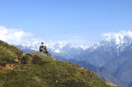
Bhilangana, the valley offers the most paranomic view which portrays the snow
capped peaks and also the hanging glaciers to the visitors. Kirtistambha and
Meru are highly sublime and offer magnificent views. It is a high altitude
trekking and can really be tiring, but we take the utmost care of the tourists
and offer facilities to overcome any strenuous situation.
The Khatlintg glacier is a lateral glacier, at the source of river
Bhilangana. Sahasratal and Masartal are on the west and east of it. The valley
of Bhilangana affords a panoramic view of snow capped peaks and hanging
glaciers, viz. Jogin group, Kirti stambh and Meru are sublime and magnificent.
At beginning the trek passes through thick forests and beautiful lush green
meadows. In the rainy season, the meadows burst with splendid flowers. Later
one have to cross two high passes above 17000 feet and negotiates glaciers,
moraines and snow patches.
The Sahasratal trek is along an old pilgrimage route to the holy lakes.
According to legend, the Bhilanganga river was created when Shiva transformed
a celestial nymph into the river. The Khatling Glacier itself is a lateral
glacier, at the source of the river Bhilanganga.
Sahasratal and Masartal are to the west and the east of the glacier.
The trek passes through thick forests and lush green meadows. In the monsoons,
the meadows abound with flowers and a number of streams mushroom out of the
valley. The Bhilanganga valley affords a panoramic view of snow-clad peaks and
glaciers such as the Jogin group, Kirti Stambha and Meru.
Day 1 Arrive Delhi
Upon arrival at Delhi met our representative and transfer to hotel for
overnight stay.
Day 2 Delhi - Rishikesh (230 kms/6-7hrs)
Early in the morning catch an Ac 6.50hrs to Haridwar and meet with our Guide
and transfer to hotel check in at the hotel. Evening free in Rishikesh. Dinner
and overnight stay at Hotel.
Rishikesh : Situated at the foothills of Garhwal hills along Ganges,
Rishikesh is a gateway to the important religious places of Badrinath,
Gangotri, Kedarnath and Yamunotri. Places of interest includes visit to Bharat
Mandir the oldest temple in Rishikesh, Neelkanth Mahadev, this is believed to
be the place where Lord Shiva drank the poison churn out of the cosmic ocean
among many other temples. Also visit some of its many Ashrams: Ashrams are
centers for spiritual studies, meditation, Yoga, sacred prayers besides being
residential centers for the resident gurus.
Day 3 Rishikesh - Uttarkashi (170 kms/ 4-5 hrs)
Morning after breakfast proceed for Uttarkashi (1150 mts), which takes 5-6
hrs. Upon arrival check-in at Shikhar Nature Resort. After lunch visit NIM
(Nehru Institute of Mountaineering) Institute & Museum.
Uttarkashi is the principle town in the region. Nehru Institute of
Mountaineering is situated here. It is also the gateway to many mountaineering
and trekking expedition in Gangotri area.
Day 4 Uttarkashi - Malla (25 kms) - Sillachhan (9 kms/6 hrs)
In the morning after breakfast drive 25 kms to Malla and from here 9 kms trek
to Sillachhan with packed lunch The trek is continuously uphill, and one must
take care not to overexert on the first day of the trek. Sillachan (Silla
Chhanis) are the temporary dwellings of the cow herds of the adjoining
villages, since the thawing of the winter snows are responsible for the lush
green grass that grows on these meadows. Dinner and overnight stay in tents.
Day 5 Sillachhan - Kush Kalyani (2040 mts/6692 ft) - Kushkalyani (11 kms/6
hrs)
In the morning after breakfast trek to Kushkalyani a beautiful grassland on
the upper reaches of the mountain, with its undulating ground covered with
grass. The trekking is much easier on this day while traversing this terrain
as one is not required to negotiate steep inclines. Kush Kalyani is named
after Lord Rama�s sons Lav and Kush. In the backdrop one can see Draupadi ka
Daanda (Draupadi�s mountain � named after Draupadi from the epic � The
Mahabharata), and Jyonli 1, 2, and 3 series of mountains.. Dinner and
overnight in camp.
Day 6 Kushkalyani - Kyarki Khal (4077 mts/13373 ft) (14 kms/6 hrs)
After breakfast trek to Kyarki Khal via lush green meadows, waterfalls and
much more. The route traversed on this day takes one on a series of ups and
downs, as the initial 2.5 � 3 kms are an ascent, and the latter part of the
day�s trek takes one over the pass into Kyarki Khal- a descent of over 5 kms.
Dinner and overnight stay in tents.
Day 7 Kyarki - Parital (18 kms/7 hrs)
Post breakfast, continue the trek to Parital taking a series of ridges one
after another via a Kyarki Bugyal. If done in peak summer months, this area
assumes a hue of yellow, as the tall grass wilts to a hay coloured yellow, and
provides the local villagers ample opportunity to stock up on their previously
dwindled grass supply. Pari � means Fairy and Tal � means Lake: It is believed
by locals that in the days of Satyug when Gods roamed these areas, fairies
would dance near the lake to please them- hence the name Parital! The lake
itself is fairly small, and not much to look at, but the surrounding area is
surrounded by staggering natural beauty! Dinner and overnight in Camp.
Day 8 Parital - Sahastral (5000 mts/16405 ft) (12 kms/6 hrs)
After breakfast, trek to Sahasratal via Taddiudyar with packed lunch. The
initial part of the trek takes an upward route and the distance covered is
within the range of 2.5 - 3 km- thereafter the downhill stretch covers an
additional 4 � 4.5 kms, bringing one to Sahsratal. The name �Sahsra Tal� means
- 1000 Lakes! Visit to this divine lake is in itself a religious yatra! This
lake is located on the western end of Khatling glacier, the Sahastra Tal of
Uttaranchal allures a number of trekkers and adventure seekers offers
excellent panoramic view of the Himalayan peaks and glaciers. Watch the
magnificent glaciers of Jogin group, Kirti Stambh and Meru glacier. Dinner and
overnight in camp.
Day 9 Sahastral - Kalyani (2683 mts/8800 ft) (16 kms/6 hrs)
In the morning trek to Kalyani with packed lunch. Sahsratal is located on the
mountain and Kalyani is located in the valley originating from the Khatling
Glacier. The descent takes one on the thickly wooded ridge and the way is said
to be very trechearous the path has to be searched and it is not uncommon to
get lost here with the service of a professional guide. On reaching the base
and camping ground is small and undulating (but can support upto 20 tents if
tightly packed! There is a nearby water source Dinner and overnight in camp.
Day 10 Kalyani - Kharsoli (2896 mts/9489 ft) (11 kms/5 hrs)
In the morning trek to Kharsoli via Biroda with packed lunch. Kharsoli used to
be an unblemished meadow earlier. Now it has been bifurcated by the dried
stream, full of boulders. A few years back, the stream just above the Kharsoli
meadow changed its regular course and ran through the middle of the meadow
leaving behind a gigantic scar in its wake. The approach to Kharsoli ascends
all the way, through the small meadows and small clumps of stunted trees
consisting of Rhododendron and Birch. There is a wide array of flowers all
along this route. The camping point at Kharsoli is a rather uncomfortable
undulating and inclined surface on a ridge top! Dinner and overnight stay in
tents.
Day 11 Kharsoli - Tambakund (3413 mts/11195 ft) (8 kms/5 hrs)
In the morning trek to Tambakund with pack lunch. Next morning we started for
Chowki. There are numerous glacier-fed streams flowing down on both sides of
the river. The trek passes through meadows and a thick good tree cover; across
the valley on the other side steep mountains with innumerous streams and
waterfalls can be seen. Arrival at the river bed followed by an ascent flanked
by a towering mountain on one side and high ledge on the other. Continuing the
ascent the tree gives way to barren mountainstill the tree-line is crossed
followed by a massive land-slide region. The careful and safe negotiation of
this obstruction brings one to Tamba-kund. Dinner and overnight in camp.
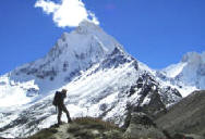
Day 12 Tambakund - Khatling Glacier- Chauki (3717 mts/12192 ft) - Tambakund
In the morning trek 3 kms trek to Khatling Glacier with packed lunch. The
visit to Khatling glacier is only possible till the �Zero Point� and one can
only go another 500 metres or so over the glacier (the detailed visit to the
glacier takes 2 days) .Since the remaining part of the day is spent in the
return trek back to Chauki, the photos are quickly taken and preprations are
made till 1PM In the afternoon, return trek to Tambakund. Arrival after a 2 km
descent to the river bed is followed by crossing a makeshift wooden bridge,
that is made by local shepherds every year (without any Government help), as
it gets swept away each monsoons! A 2 � 2.5 Kms ascent is continuously flanked
by a towering mountain on one side and high ledge on the other. Crossing the
makeshift bridges above the fast flowing river beneath is an experience in
itself. Chowki.is a welcome sight after the ascent! This beautiful meadow is
an oasis of wild flowers, green grass, and the legendary flower �the Bhrama
Kamal�. One will also find many shepherds and hundreds of sheep here. This is
the area falling within the Kedarnath National Park. Dinner and overnight in
camp.
Day 13 Chauki - Masar Tal (3675 mts/12054 ft) 6 kms/3 hrs
In the morning trek to Masar Tal with packed lunch. The trek goes uphill from
here continuously from the word �Go� till one reaches the windy Campsite at
the top- marking the day�s end!. As the trek progresses the view of the peaks
around and the Khatling valley become even better, and the bluish-green
Bhimtal lake can be seen down below. The Doodhganga � aptly named for its
frothing white colour - falling down from the glaciar appears like milk, and
presents a staggering sight. Progressing further, the Khatling Glacier finally
looms into view. A small place serves as a camping ground near Masartal.
Dinner and overnight in camp.
Day 14 Masar Tal - Vasuki Tal (4135 mts/13563 ft) (15 kms/6 hrs)
In the morning one starts for Vasuki Tal via Mayali pass (5400 mts) , when one
has to cross the Mayali glacier to reach Painya Tal and Teental with packed
lunch. This is a crystal clear pearl set in an unrivalled setting the Vasuki
Tal Lake is next. All the lakes are 1 kms apart from each other and present
difficult terrain consisting of boulders and loose moraine. From Vasuki Tal
the Vasuki Ganga starts which mingles with the Mandakini at Sonprayag.. Camp
on the side of the lake with breathtaking views of the snow clad mountains.
The lake is named after Vasuki the serpent � According to our ancient
scriptures-, Vasuki allowed the devas (gods) and the asuras (demons) to bind
him to Mount Mandar and use him as their churning rope to extract the ambrosia
of immortality from the ocean of milk. Dinner and overnight in camp.
Day 15 Vasuki Tal - Kedarnath (8 kms/4 hrs)
In the morning trek down to Kedarnath with packed lunch. The initial 2 kms of
this trip is a steep climb till the Vasuki top, from where one can clearly see
the Kedarnath temple, Kedarnath peak, Meru Parvat, Sumeru Parvat and the Manda
Parbat. The next 6 kms are a continuous descent terminating near the Kedarnath
Bazaar. The temple is magnificent in its style and architecture and to
construct such a temple at this height over one thousand years ago must have
been quite a feat. It is the abode of Lord Shiva and one of the famous
Jyotirlinga. Dinner and overnight stay in TRH/ guest house.
Day 16 Kedarnath - Gaurikund (14 kms/4 hrs) - Rudraprayag (130 kms/4 hrs)
After breakfast trek down to Gaurikund with packed lunch. As per religious
texts Goddess Parvati meditated here for a considerable time to win a consort
in Lord Shiva, Gauri is another name of Parvati. Also a famous temple of Gauri
is at Gaurikund. Further drive to Rudraprayag. Dinner and overnight stay in
hotel/ Tourist rest house.
Day 17 Rudraprayag - Haridwar - Delhi (160 kms/6 hrs)
In the morning take a holy dip in the confluence (Mandakini & Alaknanda
River). After breakfast drive to Haridwar.In the evening take Ac train for
Delhi on arrival at New Delhi railway station meet with our representative and
transfer to the hotel. overnight stay at hotel.
Day 18 Delhi Departure (210 kms/5 hrs)
In the morning transfer to airport to catch your onwards flight.
For Further Details and Booking write down us or call us :
Corporate Office![]()
( A Unit of Adventure Trekking)
Nanda House Auli Road Uttarakhand India
24 HRS contact number : + 91- 09837937948 / 09759675791 / 09412439693
Email:
nandadevitrekking@gmail.com
CHAT RD : MSN : YAHOO : SKYPE : garhwalhimalaya
Visit us: www.nandadevitrek.in / www.valleyofflowerstrek.in
![]()
![]()
![]()
![]()